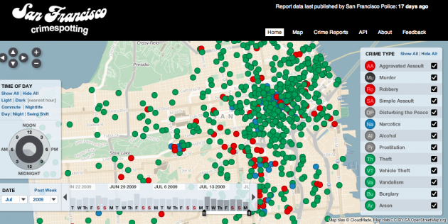
 There’s nothing cool about crime, but Stamen Design comes pretty damn close to making it cool with the new site it built and designed, San Francisco Crimespotting, that launched today. The site offers a visual representation of reported crimes in the city during a set period of time. Various types of crime ranging from alcohol-related to theft to murder are represented by different color dots placed on a map of the city.
Not only does this visually show you possible trends in various types of crime, but you can manipulate both the date range an time range to further drill into the data. Not surprisingly, there are more crimes committed at night, but it’s interesting the trends in crime during some months versus others. If you zoom in, you can click on any of these dots to get more information about the actual crime, including the police report number.
As the site describes it, Crimespotting is “a tool for understanding crime in cities.” It also notes:
If you hear sirens in your neighborhood, you should know why. Crimespotting makes this possible with interactive maps and RSS feeds of crimes in areas that you care about.
We’ve found ourselves frustrated by the proprietary systems and long disclaimers that ultimately limit information available to the public. As citizens we have a right to public information. A clear understanding of our environment is essential to an informed citizenry.
The San Francisco launch follows the Oakland version of the site in 2007, as LaughingSquid notes. But the San Francisco version features several of the newer updates including the sort-by-hour and days feature.
One thing that would make the site even better is if there was real-time data for crimes being reported. Unfortunately, much of the data is days or even weeks old, as the site clearly notes along the top. But the APIs for this data could lead to even more interesting uses. You can find out more about those here.
The site is quick to note that it is in no way affiliated with the city of San Francisco or the SFPD. Again, it just uses the publicly available data to build these maps.
