
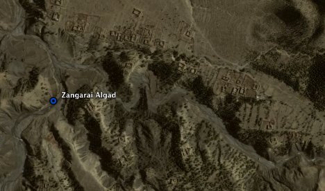
The leader of Pakistan’s Taliban, Baitullah Mehsud, may or may not be dead after a CIA missile hits his father-in-law’s home in the remote “Zangarha area” of the country. But now we can see exactly where that missile hit, and we don’t even need access to a spy satellite. Thanks to Google Earth, we get the image above.
Stefan Geens pinpointed the location on his blog Ogle Earth using location information gathered from news accounts. He also figured out where the supposed burial ground was. A decade ago, only a handful of people would have had access to such satellite imagery. Today, anyone can download it for free. CIA and military satellites are still higher resolution, but it makes you wonder how fast the geo-information gap between governments and citizens is closing.
We’ve also seen recently how the Untied States Holocaust Memorial Museum is using Google Earth to graphically document the ongoing genocide in Darfur. It is becoming increasingly more difficult to hide from Google Earth, which makes us all Big Brother in a sense. That’s a good thing (better us than a single government or corporation).
Unfortunately, Google Earth is only retrospective. You can’t see what is happening across the globe right now. Maybe one dayit will be closer to real time.


>You can’t see what is happening across the globe right now. Maybe one dayit will be closer to real time.
I can’t wait, twitter will become even better.
True. Above that, imagine what other dozen apps and websites will do?
That will never happen. The security implications are enormous.
Pakistan should first build roads there first. Regional discrimination and neglect shows even from satellite.
that’s spooky. Are they gonna have a ‘missile forecast’ service or something?
you say who needs spy satellites, i say who needs google earth?, when you can FEEL the missile hit outside your window?
A real-time Google earth would be…scary. I don’t mind not having that sort of technology readily available for people. I can live with the government following my every step, but not say…an ex-girlfriends or someone along those lines.
“I can live with the government following my every step…”
Sad comment…. very sad.
It’s very scary, terrifying even… but once the technology exists, you know somebody has it, and at that point the least terrifying option becomes letting *everyone* have it, in my opinion anyway.
(the same is not true for everything)
But yes, a real-time Google Earth would change the world. It would hard for Google (or any company) to figure out how to roll that out to the public though. Look at the protests over street view!
You are correct – Google Earth is not in “real time” but you can see anywhere on the planet.
Very cool and very fun!
HollyM
http://www.thessayist.com
-1
i have always thought of Google a Everyone’s Spy Satellite minus real time as you put it
They take a pix of me and I’ll shoot em out of the sky …
Right. Who need satellite?
USA replace satellites by a balloon: http://bit.ly/6UmpL
“Untied States”?
Dyslexics of the world UNTIE!
LOL.
“Excuse me, I think your States have come untied.”
“Maybe one dayit will be closer to real time”
This sounds very interesting.This might be helpful to monitor some activities regarding about the missile.
Pretty cool; perhaps they will have “street view” in Pakistan some day. Google Earth, Voice, Gmail, Docs, Checkout, Search, Android, Chrome… Google Everything.
Street view after the IED goes off and the streets littered with bodies. Maybe you can see one of those google cars hitting hitting an IED in action or better yet, be installed on a suicide bomber’s vehicle so we can get everything in real time.
BTW, if the suicide bomber does drive the car, does google have to pay for their services?
Terminated, with cause
Not at all where I was going with that.
If you think there is anything funny about IED, suicide bombers or anything of the sort… you are a very sick person.
Please correct the spelling of the name of the United States Holocaust Memorial Museum in the article. Thanks.
I still like a good spy satellite personally, can we have both?
I think there is this restriction put by the Govt on google earth, that the images shown should be atleast 3 years old.
Also, bow about real-time street view
???
Yea, but can they see where all my lost socks are?
“But now we can see exactly where that missile hit, and we don’t even need access to a spy satellite. ”
With ’spy-satellite’ you mean one of those satellites that takes pictures of the Earth from space? The same kind Google gets its pictures from? Ah, so you do need access to a spy satellite.
Duh!
So the US can drop a hellfire missile into the Pakistani Taliban leader’s father-in-law’s living room, but I still can’t get Domino’s to deliver a pizza to me 5 miles outside my county seat. I do hope the people of Pakistan someday understand how drones in their skies benefit them and their country in the long term. http://www.news...s/the_drone_war
How close are “the civilians” to catching up with “the military” technology? I’d say about as close as when GPS first became available to civilians…about 20 years behind. The military decides what and when technology is made available to the public.
it this will soon get realtime, no need to deploy military.
I like it better when you can see women sunbathing on roofs
“Untied States” and I thought they were United…
I think we should have satellite controlled autofiring missiles to protect any intrusion from through border.
I totally disagree from your last two lines, i think it is possible and not much known yet but to some.
You want a full satellite list, visit http://www.geosats.com and be happy !
Regards
Wayana