 As an online entity, Google is constantly evolving and improving its products. Some updates are silly, but some are far more serious and meant for good. Its update today to Google Earth to expand its Darfur coverage, is the latter.
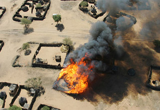
Using data from the U.S. State Departments Humanitarian Information Unit and working with the United States Holocaust Memorial Museum, Google now shows more than 3,300 villages (yes, entire villages) that have been decimated during the genocide. Google notes that while the numbers have been known for some time, actually seeing the decimation in more detail than ever before provides a clearer understanding of the devastation.
For example, using the service’s newer historical data feature, you can see before and after pictures of the region. The results are pretty stunning. This feature is available on some 200 of these sites in the region.
All of this data is available in the Global Awareness folder in Google Earth. And Google is urging people to visit the U.S. Holocaust Museum Memorial website to find out more about what you can do to take action about the atrocities in Darfur.
While talk has seemed to die down in recently months about Darfur after the election cycle made it a hot-button issue, it remains a very serious situation. And it’s good that Google is using its long reach to keep the spotlight on it.