
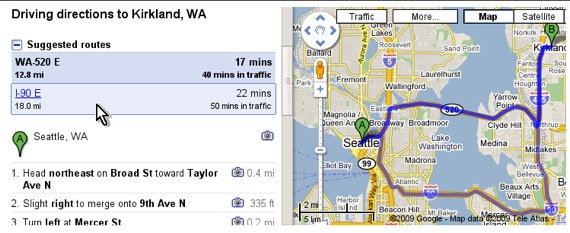
Sometimes there are many ways to get from point A to point B, whether you are walking or driving. Until now, Google Maps’ directions feature has given you the route they consider the best and allows you to drag and drop the route to change your path. Today, Google Maps is adding functionality that suggests additional routes so that you can see all of them on the map for comparison.
Under a “Suggested Routes” heading, you will now be able to access other routes to the same destination. This is a feature that GPS systems in car, like a Garmin device, have been offering for quite some time so it makes sense that Google would want to catch up. Google says that they choose alternative routes bases on many factors, including distance, travel time, and number of turns. Google Maps boils this data down to what is the lowest “cost” and ranks the routes based upon the “cost.”
MapQuest doesn’t suggest alternate routes but the site does let you choose alternate routes by filtering directions by no toll roads, highways, and distance, which is a function Google Maps has as well.


Check out http://www.twibeo.com the twitter with photo and video sharing capabilities.
oh, this is supposed to be new. anybody working in field should have known, long back.
Google is just too clever, they update make so many services and they always make new so many new features!
I think that Google is using OR (Operations Research) techniques for this capability.
Such route finding optimization is available from ILOG (an IBM company), where they have been world leader in the domain of OR softwares for many years (still today).
I think that the next revolution in route finding optimization arrives, when there are sensors installed on corners of every street, so that so that the status of the traffic can be relayed back to the software to be included as a variable in the optimization task. There is no point in suggesting a shorter route from A to B in which the traffic is heavy/slow, whereas an alternative route A –> C –> D –> B is much longer (distancewise) but there is hardly any traffic (ie, it is almost empty). So, it would be much faster to take A –> C –> D –> B rather than A –> B. ILOG can handle these types of multivariable optimizations.
Great idea, ur so right on. I can’t think of anyone who drives who would not want this. Let’s see who get’s there first.
We don’t need sensors on every corner, we just need to feed back information from the cell phones already on the streets to see how fast they’re moving. Nokia already has a pilot project to do this, but you have to be running the app – would work much better if Google could link up with one or more of the carriers and obtain the information directly (and anonymously).
It would be cool to see that kind of data put to use in optimizing traffic signal timing.
that is soooo old news.. that has been happening for over half a year…
Google maps has literally changed my life. It’s so easy to use, and they keep making it more intuitive. I want to make love to Google.
I hope they add this to public transit. Sometimes it has alternate options based on departure time, but often times they suggest a route that is not “informed.” I live in Chicago and it will often favor buses, but I know from experience that if part of your trip can be on an el train it’s better to take the el train. I’d like to be able to nudge it that direction so it can fill in the gaps with buses.
some may disagree, but the truth is i really like google tools.
Really cool. To me Google Apps are the standards I compare my work to when designing usable intuitive applications. Since we are on the topic of routing, check out this cool demo of custom routing. Ever wanted to route through a building? across a parking lot? or even between buildings? http://www.googlemapsdev.com/
Great for university campus maps!
Hopefully the suggested alternative route will be better than the alternative routes that I get from my rental car’s GPS. Last month, while in LA, it wanted (err… more like demanded) me to go over 100 miles (not a typo +100 miles) to avoid a 5 mile back up.
I would love to see Google go one step further with this and explicitly compare the costs — in both tolls and car expenses — as well as the time. Such a feature wouldn’t add much in the vast swaths of the country where toll roads don’t exist, but it would be a handy addition for toll-heavy parts of the country.
this is a pretty cool feature, as during our last #pizzatweetup from http://www.worstpizza.com the place was on the map wrong, and everyone seemed to get lost.
Does this mean it would reroute me around traffic now? Cuz yesterday google maps put me right in the middle of some bad Portland traffic. That would be a cool feature.
Yup, that would be a useful feature to have – to track traffic jams etc. It’d be nice if they could include suggested routes for public transport as well – I tried it, but doesn’t seem to be able to provide suggestions. I’d usually have to go to the public transport providers’ sites to get what I need.
People still use MapQuest?
We built a mapping mashup using Google’s mapping API to calculate the cost of driving based on fuel prices at the origin and likely refueling points along the route (www.cost2drive.com)
Be nice if they include this functionality in the free mapping API so people can compare fuel costs as well as distance and time.
I don’t get it… This is really old news.
Google is doing great!! they are making our lives easier everyday…being new in NJ/NY area i often use the drag n drop of alternate route, and avoid tolls, etc. now, the alternate routes feature really makes it almost perfect!! love google maps…
Exactly!! This is exactly what I’ve been waiting for. If it were only available on the iPhone now
.