
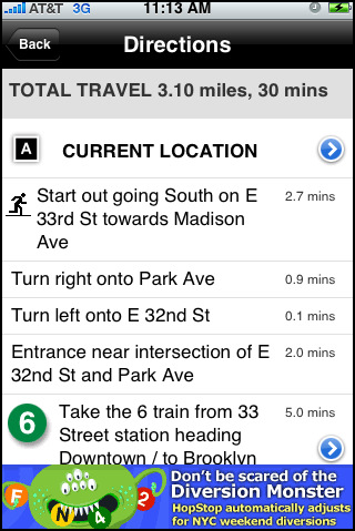
Transit planner HopStop launched its free iPhone application last week to rival the mobile version of Google Map’s Transit option. The application, with support from iPhone’s GPS functionality, offers all the same services as the website. This includes trip customization, maps marked with nearby subways and bus stops, a taxi mode that estimates time and cost of travel and contact information for taxi companies, and the ability to re-route a transit plan that is provided.
In the past, Hopstop was ahead of competitor Google Transit in terms of providing transit info for a widespread amount of metropolitan areas but Google has caught up (and maybe surpassed) with its Maps-based transit planner. And Google Maps is integrated with iPhone 3G’s GPS, making Google Transit a free native application that doesn’t have to be downloaded.
The first reviews posted on the iPhones apps store were fairly positive. Let us know what you think of the HopStop app in comments. Is it better than Google Transit on the iPhone?


I could run 3.1 miles in under 30 minutes. “Rapid” transit?
They should add a feature that let’s users with gps declare the Id of the transit line they are currently riding on. Then I could get real time info on where the hell my bus is at. Dude, I’m totally late.
http://tinyurl.com/ahzvtb
I always noticed Hopstop to over estimate time.. which is not a bad thing, but great service!
I’m still waiting for MetrO to be ported to the iPhone. It’s the gold standard on Palm, and it’s supposedly in the works now.
Google hasn’t done a good job in this space. If the MetrO port is 50% of what it is on Palm, it will be perfect.
google doesn’t need to do a good job here. unfortunately, what they do is good enough–draw more page views. pretty damn hard to compete with native-running free apps!
They should add a feature that let’s users with gps declare the Id of the transit line they are currently riding on. Then I could get real time info on where the hell my bus is at. Dude, I’m totally late.
Check this out
http://whiledis...k.blogspot.com/
I know the subway real well. And anyway, I would not be caught asking directions – so I never use HopStop in the city (NY that is).
BUT, I do use it when I travel. Given that they add on average one city a year – I am betting on Google.
The only explanation I can find for their millions of page views is that people just don’t know that Google does this. Kind of like 30 M people using Mapquest while Google was evolutionary steps ahead.
There’s a fundamental difference between these two apps. HopStop first selects a city then focuses on giving you directions within that city. Google starts out with “where do you want to go in the world?”
Try getting transit directions from here to 10th & 45th on Google and it’s just as likely to send you to Kenosha WI unless you specify 10th & 45th, NY. Maddening.
HopStop is far easier to use for transit directions. Google works great for longer distances (city to city). Being native doesn’t make the process faster for Google. Using the HopStop app is much faster.