We all know how tagging makes the Web a richer place (by tapping into people’s desire to categorize things and share those categories, ad-hoc though they may be, with the everyone else). Tagging brings a bottoms-up order to the Web by making information more searchable and thus easier to find. Now it is time to start tagging the world. The real world.
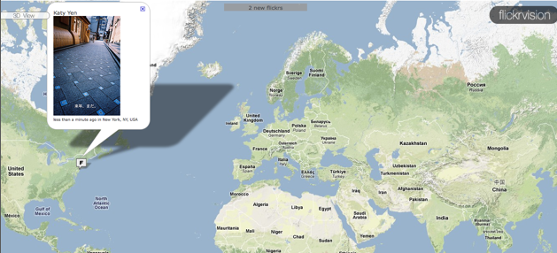
In fact, millions of people are already doing so every time they upload a geo-coded photo to Flickr, add a review to Yelp, Tweet about a specific place, or use any of the dozens of geo-aware social apps springing up all over the place. They are not just tagging the world with keywords, they are commenting on it and annotating it in tiny little bursts. To get a sense of what some of this activity looks like, check out Twittervision or Flickrvision, which show Tweets and Flickr photos, respectively, on a map as they are posted to the Web.
Services such as Plazes (now owned by Nokia), Brightkite, and Nokia’s new Friend View app all combine social communications and location information, making them visible on a map.
Most mobile social networks, on GPS phones at least, put geo-labels on everything you do. FriendFeed just recently started adding Google maps for any messages that contain location information, and Yahoo’s Fire Eagle makes it easy for other services to add their own geo-location layer.
Geo-coded communications are becoming more and more common, and this is just the start. I like to complain about the increased noise level that lifestreaming services are bringing into our lives. While that continues to be a growing problem on an individual basis for people who want to tune in and use these services (“You’re at the bus stop? Great. Keep those Tweets coming.”), on an aggregate level all the seemingly useless drivel has the potential to become useful meta-data.
And this is not limited to GPS-enabled services. You can tag Tweets, for instance, with hashmark codes that act as tags for places and things (“#bus-stop”, “#centralpark”). All of these messages get dumped into databases on the Web, which are then searchable. And that is where things get interesting. Chris Brogan explains in a post titled “Secrets of the Annotated World”:
Services like Twitter and FriendFeed and Flickr and Facebook and LinkedIn and more are hosting conversations around you that might be of value to you. . . . If you’re not using services like Yelp and BrightKite, (and you could name several others), you’re missing some of the glyphs and warnings we’re leaving on the landscape to tell you about the way things are versus the way things are marketed. You’re missing chance encounters. You’re missing stray opportunities.
Again, you don’t have to get involved. It’s just that we are, and we’re passing many more notes than you can imagine.
I am glad there are people out there like Chris who are obsessive about geo-coding everything they do. They are like the early taggers, the two percent or so of people on Flickr, Delicious, and other services who did all the heavy lifting of organizing and categorizing all the data that was dumped into them. The more that data can be sliced and diced, the more useful it becomes. And location data is particularly valuable because it relates to places, people, and events in the real world.
Every geo-coded Tweet, Flickr photo, or restaurant review is adding a tag or comment to the world that is then searchable by others. It is what will make visions like Tonchidot’s Sekai Camera a reality. It is why Fotonauts, an upcoming photo app that launched at TC50, makes it easy to geo-tag every photo in an album via Google Maps or Wikipedia. Everything in the world will be tagged. But it is such a huge task that the only way to do it is if we all pitch in. (Or at least if Chris and his friends pitch in—the rest of us can freeload).