Online map mashups are about to get a whole lot more sophisticated. A startup in Arlington, Virginia called FortiusOne (based on technology out of George Mason University) is developing a service called Maker! that will let anyone easily find geo-tagged data available on the Web and map it. One piece of the service is already available: a search engine for geo-data called Finder! It lets you find sets of geographical data already on the Web, store it, and organize it, or upload your own. Both are being built around its GeoCommons brand.
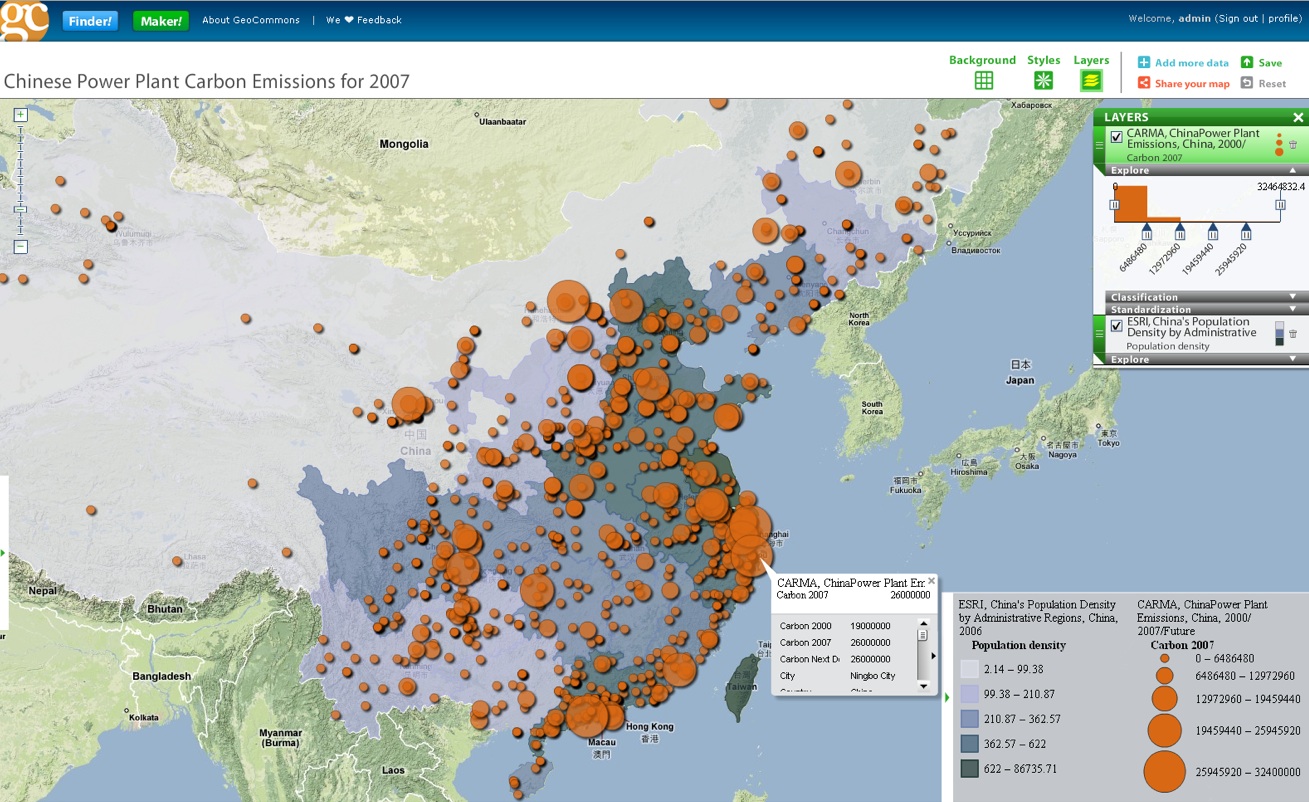
Finder! will be combined with Maker! so that all of that geo-data can be easily placed on a digital map. The company is still putting the finishing touches on Maker!, but we’ve obtained some screen shots of the types of maps it will be able to create. For instance, in the screen shot above, carbon emissions data from Chinese power plants (the orange circles) is laid over population density (the darker the shading, the more people per square mile). When you mouse over any bubble, the underlying data pops up.
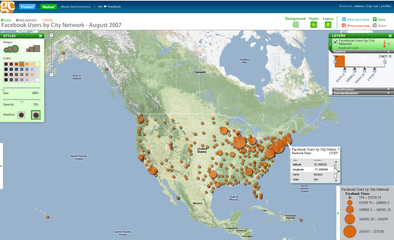
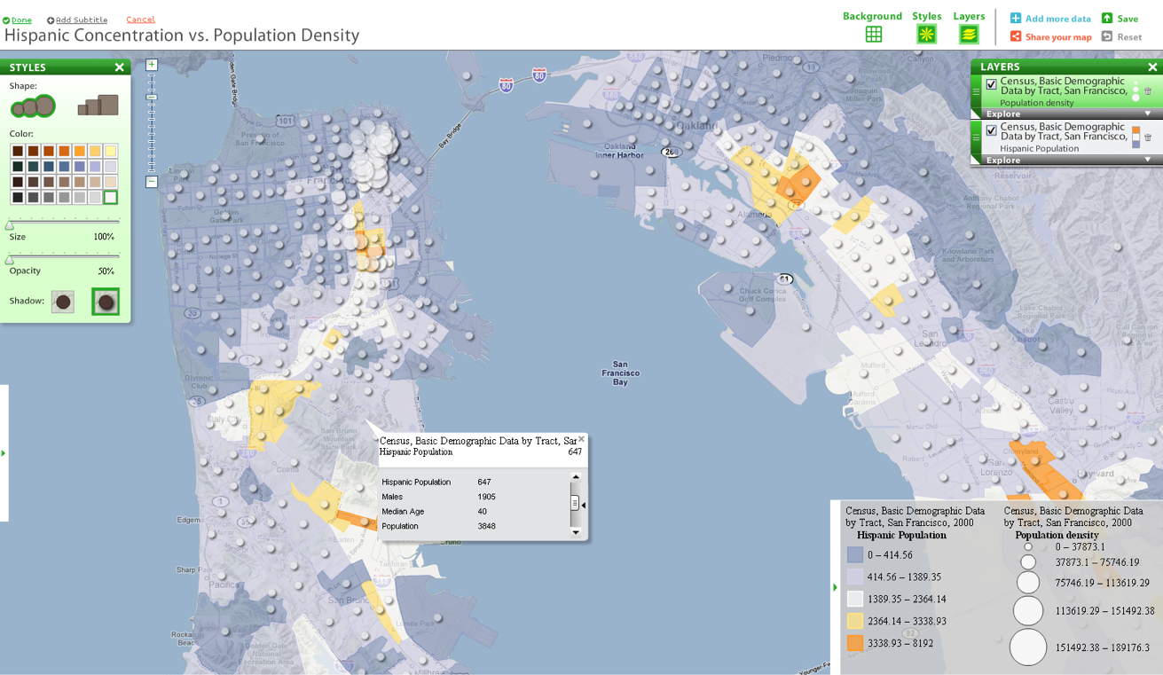
The maps below show Facebook users in the U.S. by city and a comparison of Hispanic concentration versus population density in San Francisco.
FortiusOne raised $5.4 million last year from investors that included Chart Venture Partners and In-Q-Tel (the CIA’s investing arm). Earlier this month, the company acquired geo-feed aggregator Mapufacture, which will form the basis for Maker!


Geo-mapping is crucial for many facets of everyday life but particularly in consumer retail. This tool could be specifically important for helping locate small businesses around the country. Imagine if you are on vacation and you have a map pop up on your phone telling you an icecream shop is down the street around the corner… the founder should check this out… http://www.read...ex.php?RTA=web2
Interesting technology, it makes complex tasks become simpler to execute. I´m sure a variety of fields will find use for it.
http://www.KillerStartups.com
looks lame
google map go to street level while this is just a sketch of broader area
no preciseness
they could have use google api to create this
Looks pretty cool. Do you have to have a dataset in order to create a map? I wonder how it compares to our UMapper (http://www.umapper.com) service.
It might be useful to people who are just interested in looking at data by population size, maybe nothing more. Have not used it so I really can’t be one to judge.
http://blabtech.blogspot.com
http://www.umapper.com looks pretty good, but needs more data sources. The overal functionality looks very good, i am curious to see what you guys do next.
Love the mapping applications!
Looks promising, but agree with the post regarding Google Maps API offering detail level options.
Time to do a trial….
We can understand why In Q Tel “CIA” has invested in this project. Orange spin out http://www.twinverse.com is about mapping people somehow, moving people. Combining people and objects in the same platform could open great expectations for big brother!!!
Using thematic maps together with pins create a great combination for data analysis. For marketing purposes this is awesome.
hey just a note some of your posts look absolutely crazy in google reader…. the images are overwhelming the posts… just an FYI… not sure if this is something I correct with settings.
Maker is going to be a fantastic map-making service, and when coupled with Finder, there’s really nothing else out there like it. Just a point of clarification: Maker was created by our team at Axismaps.com, not by Mapufacture (who are developing other key components of the Geocommons suite).