Free: Pack Of MySpace Branded Playing Cards »
Location-Tracking Startup Sense Networks Emerges from Stealth To Answer the Question: Where Is Everybody?
by Erick Schonfeld on June 9, 2008

citysense-small.png

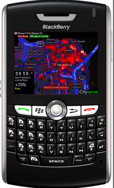
What if you could look at your cell phone and see a heat map of where everybody in the city was at that very moment? The more people at any given location, the redder it would appear on the map. That’s what Citysense does. It is a mobile application that is supposed to help you figure out where the hottest clubs and night spots are so you can go there (or avoid them, depending on your preference).

It senses where the most popular places are based on the location information emitted by everyone’s cell phones, shows the places with the most activity, and then links into Yelp or Google to help you find out what is at that location. Over time, it learns about where you like to go (fancy restaurants or punk rock clubs) and shows you other people like you, and where they are—right now. And it does all of this anonymously. (You can’t see your where your actual friends are). Citysense only works in San Francisco right now. It is available as a mobile download for the Blackberry and soon for the iPhone as well.

The application is essentially a demonstration for a startup called Sense Networks that is emerging from stealth mode today. Citysense is built on top of the company’s main technology platform, Macrosense. The company ingests billions of data points about people’s location from cell phones, GPS devices, WiFi, and even taxis. The company also collects geo-location data from everyone who downloads Citysense, or any future app (although, the company considers the data to be yours, and you can delete it from the database at any time).

Using machine-learning algorithms, it then indexes all of this location data and ranks places in the real world much like a search engine ranks Websites. But instead of looking at Web links, it looks at how much data (i.e., people) are moving between locations. The company makes money by selling this data in the aggregate to professional investors and financial institutions, who are keen to find out things like where people are shopping.

Sense Networks was founded by MIT computer scientist Alex Pentland and Columbia computer scientist Tony Jebara back in May, 2003. But it remained pretty much a research project until the company was incorporated in 2006. In April, 2008 it raised an A round from hedge funds (including Passport Capital, Drobny Global Asset Management and the Challenge Funds) and angel investors. The amount was not disclosed, but VentureWire reports that it was $3 million.

Advertisement

Responses

Comments rss icon

  • Awesome idea – ties in nicely with local advertising – Good Luck Citysense – go for it!

  • baah-baah-the-black-sheep - June 9th, 2008 at 5:28 am PDT

    Cool stuff. Can it show my boss as a big red smudge on the map?
    Better still, can I upload a list of all my managers to steer clear of troubles?

  • So where did they get access to all this data of where people are? Obviously all those people dont have their application installed. Their site mentioned “using data from the last few years” Does that mean they bought a chunk of data from a handful of cellphone companies?

  • Does anyone know if it is restricted to US cities or if it is available for the rest of us?

  • Congrats Greg and team!! Offline human behavior indexing is an untapped goldmine with limitless possibilities. I’m looking forward to all the creative applications people dream up once they get their heads around the power of this real-time mobile data. Exciting stuff.

  • This is really cool – a little worrying Big Brother-wise.

  • Can anyone actually get this to work? I’m trying to get it on my blackberry but it doesn’t load.

  • Cool. very cool indeed.

    They’ll get offers from the big boys coming in before too long!

  • I truley hope this is not going to be another meetro. Make sure you read the guest-post from the former CEO… If this kinda business and network finally reaches critical mass – AWESOME! Looking forward to this! Last question: Did they solve the battery-life-issue? The German location-aware-startup-apps drain my cell like sun melts icecream.

  • This will open a wide range of Advertising Campaigns and Strategies and this could be used as Page Rank for the various places. Can be also used for traffic minimalization and also for effective traffic management

  • @3, yes the company buys its data from a variety of sources.It wouldn’t say who exactly, but from the descrioption of its technology it must be getting data from the cell-phone companies or some aggregator, perhaps through E911 rules.

  • 1984 is coming soon to a handset near you!

  • Mr. Schonfeld – quick question – when TC posts a new story – why don’t they post it with a timestamp? Just wondering…THANKS!

  • that would be nice to have in a city like singapore, there isn’t much to do. everyone is like indoors

  • Perhaps someone with some knowledge of frequencies just used interference data along with signal strength and compared it to a few local satellites/towers, I’d imagine if the coders are worth their weight, then they could pull it off quite easily. Also, no one’s gonna call their bluff when it’s not really all that accurate.

  • Sad that this is only available in San Fransisco. Is somehting like this plausible for smaller cities or do you think that would be a ways away?

  • Perfect for our terrorist friends to identify the highest concentrations of targets for maximum carnage… way to go!

  • FluffMcFluffster - June 9th, 2008 at 7:19 am PDT

    Great idea except it leads itself for the worst possible use ever: locating large numbers of American tourists and “disrupting” them.

    Imagine if Palestinians used this in Jerusalem to track the greatest number of “targets”. Currently they pick a night club or busy intersection — they’d use this system to refine their “work”. This will be great until someone figures out what I’m thinking.

  • their next project… filter out the men, so I can find where the women are (or vice versa for others). i hate sausage parties! seriously though, cool tool with much potential!

    this would work great with car navi/gps systems. now if they only can just add where the cops are sitting on the freeway…

  • As FluffMcFluffster says, this is tricky.
    But the potential is there, and ally it with FireEagle and you can get something huge!

    However, many have tried so far. Even dodgeball a few years back, but mainstream adoption seems not there yet !

  • A nice idea. It sidesteps one major hurdle for mobile location based social networking – attaining critical mass of users – by analyzing a ton of anonymous location data to provide interesting results from the start (people hot spots) without requiring anybody to sign up. Although that shifts the critical mass problem to one of location data, that it seems would need to be obtained city by city or operator by operator, and of user technology, which requires you to own a blackberry or iphone. The behaviour matching will also be difficult to do. Users will have to verify their precise location in order to avoid a gourmet diner getting matched with someone who loves going to the macdonalds next door for example. It will be interesting to see how useful this service can be without users being able to search for specific friends or strangers and interact with them. Is this planned for the future?

  • I do like the idea, as long as it’s an anonymous thing. Great especially if one is searching for a non-crowded restaurant to visit on a Friday night.

  • Sandy was my advisor at MIT and is a true visionary. This company definitely has vision and the technology chops to back it. I’m psyched to see what unfolds for them.

  • These kinds of apps are going to be pretty awesome, but it seems like there should be some more functionality on top. Here are some opinions about this from KPCB: http://www.zint...e-applications/

  • Actually, these guys look like they have it down. I’m excited to get it.

  • …now imagine this on our new wet dream iPhone 3G… moving back to the states N O W!

  • Little bit stalker-ish but also very cool…never again show up at a supposedly great bar only to find it’s dead that night!

  • Very slick. I hope they open up an API for this. At the least, return a “heat” number for a given coordinate or something. That would make for some great third-party apps (standalone or within social networks).

    Harry “this would help the clueless with their social lives” Wang

  • anyone know definitively where they get their data from? something does not make sense. it seems at least from what i read they they bought their historical data from a cell phone company, but they claim they return realtime data.

    from their website “Citysense is an application that operates on the Sense Networks Macrosense platform, which analyzes massive amounts of aggregate, anonymous location data in real-time. ”

    where is the massive amount of data coming from if they just launched???

  • Sadly, I really want to demo this but I get error “907: Invalid COD” on my Blackberry Curve from Sprint.

    Anyone from Sense reading this? There’s no contact info on the citysense.com web site; I’m guessing that’s by design since you guys are still in alpha.

  • Great. Now people will flock to large heat spots only to find themselves in the middle of a riot.

  • Being able to track an individual throughout the day will require location information from their personal device. While Sense has other ideas for getting location data (e.g., taxis, laptop wifi) these options do not provide the personal, individual tracking required for their tribes idea (see their website).

    Also, I highly doubt that they’re working directly with the carriers on this to get location data. If I’m correct, they’ll only be able to get data from smartphones that allow 3rd party apps to be installed and have O/S that give access to the core resources of the phone. Also, only with carriers who give access to the GPS information on their devices. Some carriers have disabled the A-GPS chip they put into many phones for all uses except E911.

    I don’t think cell tower triangulation will be enough… and wi-fi has limitations for trying to track the movement of someone throughout a city (its good at saying where you are now). That might be good enough.

    The biggest challenge that I see is battery life. Using a cell phone to ping for GPS locations frequently, and running WiFi as you move around the city on your phone will kill batteries quickly. They’ll need to convince people to leave Wi-Fi on, let themselves be tracked, and quickly drain their battery.

    I think its a fantastic idea, and I hope they’ve worked out some of these issues.

  • Sense Networks were recently profiled in this BusinessWeek article as well:

    http://www.busi...+future+of+tech

Leave Comment

Commenting Options

Enter your personal information to the left, or sign in with your Facebook account by clicking the button below.

Alternatively, you can create an avatar that will appear whenever you leave a comment on a Gravatar-enabled blog.

Trackback URL
bugbugbug