May 21, 2008

SpotCrime Keeps You On The Right Side of The Tracks

Jason Kincaid

51 comments »

SpotCrime is a mashup that plots recent criminal activity onto Google Maps, allowing users to shy away from seedier parts of towns they may not be familiar with. The company has offered a website for a few months now, and has just introduced an iPhone version (annoyingly, you have to manually navigate to http://www.spotcrime.com/iphone.php).

Crimes are depicted as small icons according to the type of incident, and users can filter crimes over a certain date range or time period. Clicking on an icon brings up more detailed information (when available). The site currently supports only a select number of (mostly large) cities, but it says that it is expanding quickly.

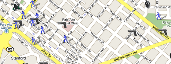
SpotCrime draws approximately 90% of its data from local police records, and, in cities where that information isn’t released, they gather it from local news sources. While most of this involves data scraping, SpotCrime says there there is still a human element required - something that will become increasingly problematic as the company grows. Incidents typically take 3-24 hours to show up in the system, so SpotCrime isn’t useful for avoiding crimes in progress. It does, however, provide a nice visual representation of criminal activity.

SpotCrime says that they are offering the service as a free tool to both police stations and the general population. While it’s hard to believe that the police don’t already know about the rougher areas of town, the visual overlays could conceivably held them identify trends. Other potential applications of the data include real estate evaluation, and (for more paranoid users) “safe” driving routes mapped by GPS.

SpotCrime isn’t the first site to do this - you can find similar offerings at The LA Times Homicide Map, UniversalHub, and a number of others. But most of these sites are regional, and SpotCrime is intent on cataloging cities across the country - something that will be hard to do unless they can find a way to fully automate their system.

  • Sphere It

Comments

I love this SpotCrime concept. It reminds me of playing CaesarIII sims type PC game where you can highlight the seedy parts of town and zoom in on rioters! Only this is for real in real time! Great innovation!


does the blue guy represent a jay walker?


Orange County is already covered pretty well by http://www.OCCrime.com


I’m gonna go out and commit a crime at Waverly and Lincoln to see if I can “connect the guns”. Wish me luck!


crimereports.com


Why can’t users embed the crime map into their own blog?
That’s terribly old-fashioned. We are living in the new world without walls suuounding our web territory, man!


Once I felt terrible when I am waiting alone in Palo Alto caltrain station during late hours. It will be useful if it also includes some symbol to indicate the timings of these crimes. Some places are safe during day but not after late hours. It is also a good tool for those who want to rent rooms in safer place.


If you want to see crime, pick Oakland, CA! There is barley room left on the map. LOL. Everybody getting muthfin’ Hyphy Dance Jamin and stuff.


This whole concept sounds ridiculous and a slap-on-the-face-of-administration-and-government. I just don’t get this idea of showing unsafe places on the web so that people don’t get settled there. What signals are we giving away by doing this? Ideally isn’t every place supposed to be safe ?


FWIW the police already have the data since they are the ones publishing it in the first place and often its already available within a mapping or GIS product of some sort. Some cities already publish their data on the web via some sort of graphical interface already, e.g. the city of San Francisco’s site. Some things that I could see SpotCrime providing would be better and more powerful interfaces, more powerful search capabilities, and standardization of access across multiple cities.

Another thing I want to point out is that SpotCrimes is purely a historical database of crimes which have already happened. As a predictive tool, as is, it is limited. A number of cities and law enforcement agencies also do predictive mapping/modeling, and there are a number of existing software packages, web pages, etc out there already.

Finally, I note that I’m totally unclear on the business model here. How do these guys get paid?

PS Crime mapping data can also be used by criminals to aid them to plan and execute crimes. This and a number of other considerations may limit the sorts of data that SpotCrimes can aggregate or make available, e.g. real-time location of police activity is not going to happen in the short term.


Re : My own comment @ #11

I think I do understand that the basic idea is not so that people shy away from the region of the crime. This site should just be treated as an example of a Mashup showing places of crime.

Got slightly confused with Jason’s text in para #1.

Peace :)


I think this whole thing is quite ridiculous.


Another issue:

I notice after poking about a bit more on SpotCrimes that the data for San Francisco seems inconsistent with the SF City’s own crime maps. For various reasons its hard to make a direct comparison, however there are simply many fewer crimes depicted on SpotCrimes. I’d be interested to understand why there seems to be such a large difference.


It’s not very accurate. A crime identified on S. Alaska street in Seattle links to a story about a crime in Southern Alaska.


hmmm….what is so “annoying” about navigating to the site on the iphone, the fact you have to type in the url? is there some other way of entering sites on the iphone browser?


Interesting, but I’d like to see Zillow laid over top of this to be able to see the impact that crime has on real estate prices.

Plus, what is with all the gun crimes in downtown PA? Facebookers representing the 650?


This project is meant for the greater good. No matter how bad this is, the intentions are good, so don’t knock it.

I wonder if they tried to come up with a business plan. Donations? Advertisement for bail bonds/life insurance? :) Information is great for home buyers.

BTW EAST PALO ALTO FTW!


@Scott Schnaars JINX


How about adding a Web 2.0 Social feature - criminals could get alerts about other cons operating in the area, so they get together for a chat and cause even more havoc.


funny, like parental-control software for the web, except for the so-called real world …. now johnny, we don’t think it is good for you to go there ..

heck, combine this with the iphone location tracking, or good old rfid chips, we can actually have the police called just before we get in trouble…

the longer i live, the brighter i think those science fiction writers were


this is the perfect comment thread, lots of humor, some good ideas, no trolls… no spam …. must have touched a sweet spot

gabe, meet you there


Of course, there’s Spotcrime.net too (As opposed to .com) - which has been around for a good year or so, apparently in stealth mode, but it looks like it’s slowly moving…
It’s got the social networking stuff that people seem to crave…


The first was chicagocrime.org. Now defunct because Adrian Holovaty wrapped it into EveryBlock.

Many newspapers have crime maps now, inspired by Holovaty.

This is nothing more than a visual representation of the Police Blotter/Police Log, which has been standard fair for newspapers for 100 years.

Nice icons, but hardly innovative. I’m not sure how it’s even worthy of a mention in TechCrunch. It’s old hat at this point in the web’s evolution.


cool, and obviously getting your iphone out in public to check whether its will automatically double your chances of getting mugged))))


holy shit HAHAHAHHA some of the cities have so much crime. I almost spit out my tea when I looked at Chicago

My smallish town of 250,000 people gets like one crime a week and usually it’s some small robbery or a lady having her purse stolen (We have a Google Maps mashup of crimes for our town too, but it’s much more boring)

But I live in Canada, that may say something

 
Livingston Waterbury - May 22nd, 2008 at 6:54 am PDT

yes…this idea interests me very much. As the heir to a large adult diaper empire fortune I believe this is just the kind of kind of services needed to power our economy in the 21st century. Now during my brisk morning constitutional as I stroll down the avenue in my tophat and monicle, I shant fear thugs and criminals lurking in the darkness…for I will have my iphone with me! with which I will be able to check the criminal activities of the past.

 
Danny McDanielson - May 22nd, 2008 at 7:03 am PDT

Ubersweet app dude!


Bart,

The problem with looking at Chicago is that the geolocation on the crimes isn’t accurate, and there’s crimes listed on there that I can’t find anywhere else, so who knows if that data is correct.


This is a really incredible application. i just checked my local town and I was surprised to see all the activity. I’m sure all kinds of industries like alarm systems, insurance, etc. could make great use of this data. I think spotcrime.com has a very bright future ahead of them.


This is a great idea. Unfortunately, right now the mashup only reveals the fact that more crimes occur where population density is highest.

A second variable needs to be introduced, and the mashup of crime with this second variable (some sort of inverse log of population density multiplied by crimes per hectare?) needs to be made into a heat map layer instead of plots.

I also think that after you use spotcrime to calculate your route, the tool should warn you when your destination falls within a danger zone (most of which are “theft from vehicle”).


Addresses are very inaccurate for New York City. Check out Manhattan - many of the addresses for outer boroughs are being mapped to Manhattan. If you can’t get the basic mapping right, what’s the point?


Wow very cool what will be next with google maps. I love the satellite view, street view, and now this i love it. GOOGLE MAPS


Seems inaccurate. It mixed up California Avenue in Walnut Creek with California Street in San Francisco.


I’m concerned for the damage this might do to property values or retail activity in an area. Without a way to time-lapse the reporting, will a crime committed 5 years ago near my house still reflect alongside other more recent crime near my home as reflected by this service? If so, the property value of my house my fall as a result.

Shall I have my lawyer launch a class action now, or later? I can smell this one coming a mile away.

Sure, the information comes from public sources - law enforcement, news media, etc. - but to use of the public sources in a way which directly causes financial damages to real estate owners or reduces the traffic for retail establishments may be actionable.

To reduce risk, the website better put a time limit - a short time limit - as to how long a location is reported on their website for a crime. That, or they better have the option for the user to select the time period.

Regardless, I know that there is at least one lawyer smelling the lawsuits already. Lawyers may call this “spotcash” instead of “spotcrime”.


Worthless. Looked at info for my city. Data used was essentially crime stories from the local news — including trials about crimes that happened a long time ago. Not sure what the point is.


Looks as if their data is pretty spotty. Only 29 crimes in the past twelve months in Detroit? Guess Grand Rapids with 162 crimes is the new crime capital of the midwest.


“SpotCrime is a mashup that plots recent criminal activity…” - in the US (!) - “onto Google Maps, allowing users to shy away from seedier parts of towns they may not be familiar with.”

Please stop wasting my time with Americentrism; it’s just stupid.


thanks for that it is very goooooood


Sorry, the comment form is closed at this time.