Google Transit Graduates From Google Labs
by Duncan Riley on October 3, 2007

googtransitlogo.jpgGoogle Transit, Google’s public transport mapping feature, has graduated from Google Labs.

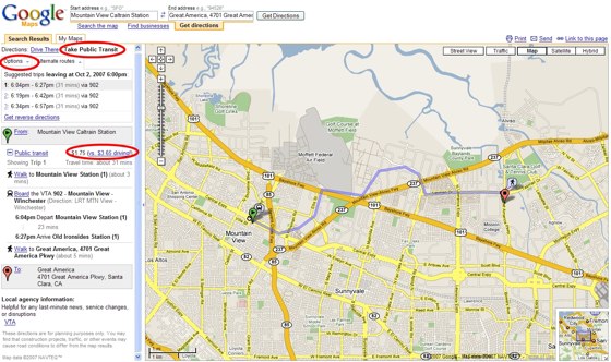
The service is now fully integrated into Google Maps, with users now being able to select “Take Public Transit” as an alternative to driving instructions.

Google Transit doesn’t cover public transport everywhere, but the list is growing. According to Google recent additions include transit maps for the Santa Clara Valley Transportation Authority, and Hampton Roads (VA) Transit and the Bay Area Rapid Transit System. Non-US transit mapping is also available for China, Japan and parts of Europe.

googtransit.jpg

Comments

Isnt this what hopstop.com is doing ?


For Japan they need to still map the stations in the English equivalents. A lot of international travelers would find it useful. If I type in the stations in Japanese it works quite well. Yahoo Japan’s Transit site you can put the stations in English or Japanese but the interface in just in English.


Actually # 1 you are right. hopstop is the same, with more advanced features like they SMS the directions as well.


Yeah hotspot does the same…well google never came out with anything original. Following the footsteps of MSFT.
http://vidsonly.blogspot.com


Been waiting for this one … this is a good example of Google crushing innovation. We came up with this idea a long time ago and said “nah, Google will do this and give it away for free. No money here … move along”.

This isn’t a great money maker but at some point it becomes a “you gotta have” feature for personal navigation (a lot of cell phone nav stuff is for pedestrian nav, not car nav, especially outside US). Google gets all this content and are the content providers (stodgy transportation agencies) going to want to create the same content for other platforms? Probably not.


You can find out this kinda’ info anywhere.
Gaggle: a huge waste of time!


@Transportation Guy: In response to your point about content, let’s set the record straight: what Google seeks to do is make it easier to discover public transportation options in the context of other useful information.

With input from several transit agencies, Google created an open, easy to use format for representing transit data, formally known as the Google Transit Feed Specification (GTFS). Despite the name, GTFS doesn’t just pertain to Google — GTFS was released under the Attribution/Share Alike Creative Commons license so that others can come up with innovative things to do with data in this format (e.g., http://graphserver.sourceforge.net/).

Two major agencies (Portland Tri-Met and BART) have already made their data available in GTFS format.

To learn more, please visit:
http://code.google.com/transit.....cation.htm

Tom Sly


Good god… DULUTH?


hopstop doesn’t seem to have good handling for misspelled addresses.

I always get “Destination address not found”.

Google does a great job in finding a location that was misspelled.

i.e. 1500 geaary, san francisco, a

even with “a”, as its state, it gets it right…..google rocks


This service/tool goes out of BETA while it’s only available in select market areas? About a dozen or so? It’s got a long way to go before it’s truly useful to a majority of users.


There goes hopstop. Poof.

They were good while they lasted. Sucks to see more wealth goto the trio at Goog.

I’m beginning to think there is no point in becoming a programmer or CS grad unless you start you’re company and become rich. If you don’t, you’ll end up a overworked, underpaid corporate tool who’ll be layed of at 40 and outsourced to India. Also, everyone will say ‘I have a friend who does HTML, is that what you do?’ You reply no, I create complex graphical algorithms or develop AI. But most people will think you design shitty websites.


Are you kidding? Google has been working on “Google Transit” since 2005. What have they been doing all this time? They have the amazingly complex city of Duluth. Come on guys!! Do NYC then we know your’e serious!!

I personally love HopStop and Google’s product in NYC would have to be seriously better for me to switch. If their NYC offering is anything like Seattle’s, ill be a HopStop user for life! :)
http://seattle.metblogs.com/ar.....s_me.phtml


Suburbs of Washington, DC are “outside of our coverage”. WTF?!?!


Now google (just) needs to setup public transport in all non-metro areas in the U.S. and this would gain usefullness. :) For all the places in Europe I tried, it redirects to Google Maps.


It’s nice to see some things coming out of their labs. It seems like they have been working less on creating new labs tools and working more on actually implementing them.


Q: are Google working with any SatNav outfits out there? If not, they should be.

Thing is, with an iPhone and Google Maps, you’ve got your very own personal SatNav, whether you’re in a car, on foot or whatever…


Google Maps used to have Manchester Metrolink stations marked on it; they seem to have disappeared for no apparent reason. Could it be linked to this?


It is exactly this type of product that, in part, pushed Nokia to acquire NAVTEQ—personal navigation. In countries like India, China and across Europe the utility of mass transit routing in your pocket on your GPS-enabled phone is extremely valuable. See full analysis of the deal’s broader implications here: http://www.gpsbusinessnews.com.....numero=408.


Blair, thanks for sharing that link. It was good analysis.


ooops.. found something interesting here…
point google maps to show the directions…

from LA (los angeles, CA) to BH (Belo Horizonte, MG - Brazil)… check out the item num. 20… c’on guys…

the biggest bug ever…


My company has a tool which helps get cities onto Google Transit. We have a web based system that allows the agency/city to manage all their data, which we then export to GTFS format. If you want your city on Google Transit, have them contact us.


Leave a Reply

Create a Gravatar for your comments.
« Back to text comment