Earthmine Aims to Index the Real World with 3D Panoramas
by Mark Hendrickson on October 3, 2007

You’ve probably tried the “Street View” feature in Google Maps, the one in which you can actually view 3D panoramas from the street level of several cities including San Francisco, Las Vegas, Denver, Houston, and New York. Earthmine is working to bring that concept of visually mapping the real world to a deeper level by improving the quality of virtualization and by enabling the indexation of objects found in landscapes.

Imagine for a second that you could notify your friends of something cool or noteworthy that you see when out on the town by simply pulling out your cellphone, bringing up a panorama of your location, and tagging something (a store, a parking spot, an historic landmark) with a note that is automatically shared with your friends. Then imagine you’re a restaurant owner who wants to entice potential customers by tagging the outside of your diner within a 3D panorama with menu information and digital coupons. None of this is possible yet, but Earthmine will provide the technology that could very well make it all a reality.

Like Google, Earthmine collects its data by driving vehicles equipped with special cameras around urban areas. Earthmine co-founder John Ristevski says that the company’s custom camera “uses a stereoscopic system with extremely wide angle lenses to capture full spherical images of the urban environment.” Webware has a good photo of one of these babies strapped to the top of a Pathfinder (it can also be seen at the beginning of the video embedded below).

Ristevski says that, unlike Google, Earthmine uses a data calibration process that preserves the camera input as an unfiltered data set, which contains a higher level of detail because scenes are stored in “pixel for pixel array[s] of ‘depth’ points.” The result: Earthmine panoramas look better. But they are also more useful, because more detail = better indexable data. The company is called “Earthmine” not because it wants to make Google Street View prettier, but because it wants to the “mine” the Earth’s data.

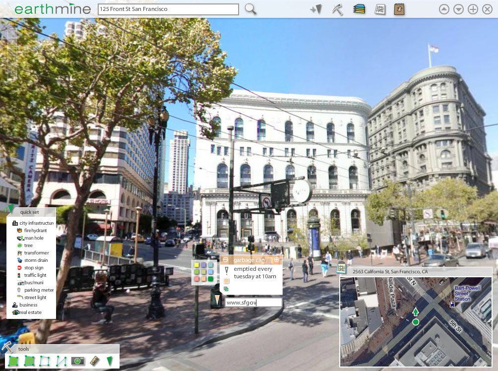
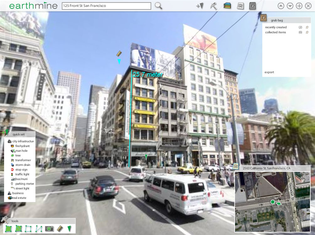
What this all means is that Earthmine’s system can keep track of the objects found in the real world and attribute information to each of them (a process known as “asset mapping”). The latitude, longitude, elevation, and other attributes of garbage cans, telephone posts, manholes, and trees can be recorded and tracked in a pseudo-3D virtualization system. The information can be exploited within Earthmine’s software or exported to GIS or CAD systems. Alternatively, the information stored in preexisting Geographic Information Systems (GIS) can be brought into Earthmine.

Not interested in using computers to identify and tag all of the objects you could just point out on the street? That’s okay, because Earthmine isn’t necessarily focusing on you, the casual consumer. The company has its sights set on bigger customers, like the government and enterprises (which is a little scary if you are a Big Brother conspiracy theorist).

That said, Earthmine is working to make mapping technology more accessible and efficient. Ristevski claims that cities the size of San Francisco can be mapped in less than 30 days. Once Earthmine takes care of the mapping, it plans to license out its 3D inventory to customers such as city governments, branches of the national government, PG&E, big insurance companies, transportation companies, and even other technology companies like RedFin or Zillow. Earthmine hopes to make its software easy to use and affordable enough for a wide-range of consumers who are not necessarily all that technically literate. Ristevski draws parallels between what Earthmine is doing for real world mapping and what Sketchup did for 3D modeling.

Earthmine presented at DEMO this fall but has not released its product yet. The company is based in Berkeley, California and has so far operated on $1M of seed money.

Check out our coverage of other companies who are innovating with 3D technology: Photosynth, Everyscape, and Fotowoosh are developing technologies that convert 2D photographs into 3D models; Microsoft has developed advanced 3D modeling on top of its Live Search Maps product, and has also implemented Photosynth technology; and VisualSize is developing a system for accurately measuring the dimensions within 2D photos.

The following is a demonstration video for Earthmine:

Comments rss icon

  • Well it definitely looks impressive.

    It sure will make it quicker for me to measure the buildings that I will be leaving explosives in. This will make life for us terrorists so much easier.

    No more sneaking around in those damned hooded sweatshirts trying to take pictures and measurements. Gawd, did I hate that! Especially on a hot day.

  • Those panoramas are really 2D with some perspective tricks. You can’t actually measure or traverse the depth of those objects, only measure the height and width (unless you turn the corner and get a new view, which is just another 2D distortion). I’d be interested in some true 3D panoramas, which would probably require some kind of laser scanning to measure the proximity of surfaces (and a lot more computing).

  • Although it looks impressive and appealing, who cares about the privacy. I do, do they.
    http://vidsonly.blogspot.com

  • Niraj is right. It’s not 3D. TC makes this mistake a lot. At some point, there will be photorealistic 3D worlds in your browser. And this system might even record range information to identify nearby objects, but it’s not enough to reconstruct the scene in 3D just yet. The newer 360 degree cameras offer 30 fps video capture as the van moves down the street, which means enough sample points to make moving along that same path look pretty seamless. But that still doesn’t let you move off the path. When you can really walk anywhere, then we’re talking true 3D. Until then, it’s no more 3D than taking a photo and holding it in front of your face until it lines up just right.

  • Both Niraj and Avi are way off point here. These panoramas are truely 3d environments, not just a series of panoramas sitting in 3d space. Perhaps the two of you are not familiar with photogrammetry, a process by which 3d data is derived from a series of 2d photographs. I have worked extensively with laser scanning (LIDAR) technology, and what Niraj is talking about would be possible, but it is not necessary in this application. By implementing multiple calibrated cameras, and gps it is entirely possible to assign a 3d coordinate to each pixel in the image. Their panos have the ability to export the index tags to other software like google earth, complete with lattitude, longitude and elevation data and by my count those are three coordinates in space (by the way in case you didn’t already understand that how many you need to construct a 3d model, thats why there is a 3 in there instead of a 4 or 5). Just because one’s point of view within the environment is fixed, does mean that that environment is 2d. Avi doesn’t get the point when he suggests that we should be able to walk around DOOM or Second Life style in some virtual world. This does not seem to be the pursuit of Earthmine. The point here is to index reality not try to recreate it. The power of their system is in its abilty to make complex sets of geospatial data high accesable, and digestable, without having to learn how to navigate the 3d CAD model or some sort of video game virtual world. Great maps are successful in their abilty to condense complex set of data, and put them in an understandable format. It seems to me that is precisely what is being done here.

  • I like this almost as much as terraserver 3d.

  • Meggers, you can click through to my bio and then tell me I don’t know what photogrammetry is. All of these competitors: Street View, EarthMine, etc… draw something akin to a cylinder or sphere of captured 2D imagery that surrounds each of a series of fixed nodes. I know exactly how it works because the technology has been around since the nineties at least. None of them yet show you what the scene would look like if you stepped anywhere other than where they took their 2D panoramic snapshots. The main difference between them is what resolution and where they place the nodes. Clicking/tagging objects is a nice bonus, but it doesn’t make it 3D anymore than a HTML image map makes web pages 3D.

    The fact that EarthMine may also be capturing/delivering depth information per pixel means very little if that information doesn’t actually add depth back into the image you see. It does not make the “environment” 3D just to say _they_ know the distance to each pixel. So what? The point of being able to walk “off-node” as it were is that it’s inconvenient to be limited to only the places (and times) where they took snapshots. It’s not a bad start, and I like all of these services so far. But it’s still very limited in what you can do.

    Now, if they can truly extract phototextured 3D models from their scans, as you say, then that’s great. Rendering _those_ extracted (textured, polygonal) 3D models in a real-time app would qualify as really being 3D. Even doing plenoptic warping between nodes would be close enough. In fact, even delivering stereo pairs to a stereo output device would be close enough to call it 3D in a generic sense, because our brains can do the depth calculation in that case (though I’d still want free movement). But to call what is essentially the same rendering technology as QuickTimeVR “true 3D” is misleading at best.

    And in fact virtualizing the scene is exactly what it will take to get past the inherent privacy problems with all of these systems. Ultimately, most people want a sense of the what the place is like, not just at the specific time the van happened to drive by, but in general. And that will mean essentially erasing people, cars, and other transient objects from the scene, and adding those back in dynamically, if there’s any need.

  • Props to Meggers and Avi for one of the most intelligent back-and-forths I’ve seen around here for awhile. I can see both of your points regarding the use of the term “3D”, and I’ll admit I didn’t spend too much time wondering about whether the label was appropriate here; it just seemed to me that it was given the way you can view multiple 360-degree panoramas from different spots in a particular area (like in Myst 3, if I remember correctly). For what it’s worth, Earthmine does claim that it will provide “a spatially accurate, truly 3D inventory of our world.”

  • While “indexation” is a word, I don’t think it means what you want in this context. You’re looking for “indexing”.

  • Really? I don’t see a difference between the two words. I actually had “indexing” in there to start, though, but “enabling the indexing” had a lot of ings.

  • Avi and Niraj are right. While cool, this isn’t really ‘3D’. A lot of people seem to get confused as to what is defined as ‘3D’ or not. I’ve found it’s difficult for those not familiar with gaming, or 3d graphics. A good way to define it is ‘can I see an object from any possible angle?(go around it, from the rooftop, underneath). If so, then you most likely have realtime 3d tech. Otherwise its more likely some fancy image manipulation.

    The difference is HUGE and its extremely frustrating when people make this mistake. We don’t yet have realtime 3d in the browser(flash can only do so much.)

  • Avi you are just splitting hairs here on what you are calling 3d. One does not need to be able to go “off-node” to make the data 3 dimensional. If you simply took all of the coordinate information in one of earthmine’s panos, and printed it out in text format, this would still be 3d, because it describes a 3d environment. You are talking about continious 3d navigation, which is not something that earthimine is claiming. Again, what earhtmine is trying to create here is NOT a virtual world. They are using the panoramas to create a framwork by which to organize 3 dimensional information. Implementing a snowcrash-like environment, as you are suggesting, would simply destroy the whole purpose of the system. 3 dimensional information organized around a simple and intuitive framework such as geospatially referenced panoramas has enormous potential for REAL-WORLD applications, such as those mentioned in the TC article. Such a data set would be an incredibly valuable resource for governments and enterprise users, for applications such as asset management where precise geospatial information may be nesessary. In order for this info to be usable however, it must be deliverable in a highly effective and highly concise manner. From what I can see of earthmine’s system, it seems to be promising to do just that. Creating what you are call in “true 3d” environment or virtual would be of little pratical use, because taken to the furthest degree, would only result in a virtual replication of real world, which is just as complex and difficult to visually manage. Rather than fantasizing about making Snowcrash a realtiy, you should take a look at what people like James Corner, or Edward Tufte have to say about the power of mapping and how to effectively organize and communicate complex sets of information. The real world is an infinitely complex place with infinite amounts of information bombarding us at all times. Attempting to duplicate this in a virtual environment seems to be of very little utiltiy beyond a visualization toy. Maybe people who like to hang out with other people’s avatars would find such a world useful, but I can hardly see any real-world utility taking place there.

  • Good and viable product.

    I can definitely imagine governments paying for this type of a service.

    Good luck selling it though.

  • Meggars, I think we all agree that you can hardly see any real-world utility taking place with what I describe as “3D.” :)

    I don’t want to drag this out, but I guess the answer lies in whether there is utility in using Google Earth vs. Google Maps. Maps provides greater reach because it’s browser-based and faster to answer casual queries now and then. But GE is much better at teaching spatial relationships. Maps is almost entirely 2D, even with Street View. Google Earth, with buildings & terrain, is almost entirely 3D.

    I’m not arguing that you must prefer or use one or the other. I use both myself. I’m simply arguing not to call any analog of Google Maps (and especially Street View) “3D” so that we honor one big distinction among the many valid approaches to mapping the world.

    Mark, I thought one nitpick was plenty, but I also agree that “indexation” isn’t a word, at least outside of economics. :)

  • Mmmmm… Daddy likes! This would be really useful for a site like ours, as opposed to the plain vanilla 2D maps you see at just about every real estate site these days.

    Only 30 days to map Frisco? Really? I assume you can only map during daylight hours, when the weather is nice, so these guys must be scurrying around like ferrets on meth. Love the work ethic!

    One thing though, as opposed to just covering urban areas, Earthmine should definitely include the boondocks as well, because whereas a lot of people know the geography of the nearest big city, nobody except the residents has a clue about peripheral suburbs and little towns. So hick places would be MORE important than the major urban areas.

    Apart from the extent of their coverage, the crunch factor would be price, I guess. I wonder if we’ll ever manage to con a VC into forking out enough cash to afford a service like this. Or maybe we can con Earthmine into taking equity?

  • Back to 2D v. 3D. An easy way to define 3D is this: “I can see the object AND I know how far it is”. The object is a 2D picture and the distance is the 3rd dimension. To find the distance you need stereo vision or radar etc. Without that, it’s not 3D.

  • What is the use for again?

    If it is another “because we can” now let’s build a business out of it, kind of thing - then with heavy sigh, I say “Oh sheesh, here we go again”

    I mean think about it….
    Let’s say that we spend $100 million making 2d/3d maps of everything.

    The people who ACTUALLY need that information could just hop on a plane, go there, see for themselves, for $3 grand. All the rest is just fluff and hype.

    AND, don’t totally take this wrong because I’m a gadget/technology freak as good as the next guy, but each day I become more realistic.

  • Impressive, but as Michael says above my post it is just one of those products that has no usage at all!

  • Thanks for great discussions. Avi is co-founder of Keyhole. Great to see somebody of that caliber commenting here.

  • Of all places to showcase in a demo, WHY choose 7th & Stevenson? Most SOMA residents like myself concur that federal building is perhaps the ugliest structure on the planet. And I hope the end product is not that high res otherwise you’d probably see the bums peeing on Stevenson St behind Mr Smith’s.

  • Do we also need to measure how tall he/she there is? No, I guess.

  • Amazing stuff and great photo technology. Really impressive.

Leave Comment

Commenting Options

Enter your personal information to the left, or sign in with your Facebook account by clicking the button below.

Alternatively, you can create an avatar that will appear whenever you leave a comment on a Gravatar-enabled blog.

Trackback URL
bugbug
The CrunchBoard
  • MediaTemple Logo
  • QuickSprout Logo
  • OpenX Logo
  • Cotendo Logo