May 29, 2007

Google Maps Now with 360 Streetside Views

Nick Gonzalez

72 comments »

googlemaps.png
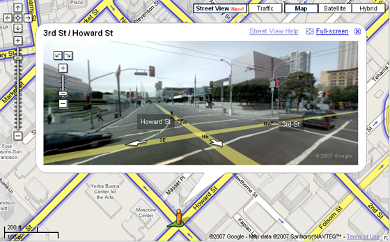
Google has will be announcing a new 360 streetside view for Google maps at Where 2.0 today, says O’Reily Radar. The 360 views are a better version of Amazon’s A9 static panoramas. Google’s views let users virtually stand in the middle of any street, able to look in a full circle around the location, giving a better feel of the place you’ll be going. It will reportedly be available in Denver, Las Vegas, Miami, New York and San Francisco.

The imaging used in the new feature was collected by a company called Immersive Media, whose vans throughout these cities to collect the photos. You can see a demo here.

Top map competitors Google and Microsoft have both been experimenting heavily in enhancing their mapping applications. Microsoft has a similar streetside view for New York and 8 other cities, which we reported on back in February of last year. Other map visualization innovations have been birds eye view and emerging 3D products. Microsoft launched a 3D product last November. Google has since licensed 3D mapping technology just this month.

googstreet.png

  • Sphere It

Trackbacks/Pings (Trackback URL)

  1. Manas
  2. Google Maps Now with 360 Streetside Views - Offtopicz
  3. Rich Internet Applications
  4. Google Maps Streetside View - Don't want to see this in London.. « Wille Faler’s Buzzword Bingo
  5. Google Maps Now with 360 Streetside Views
  6. Seeking the Wisdom of the Ages Through Our Student’s Eyes » Google Maps - 360 Views
  7. Google Maps - Street View
  8. Google Street View Adds Four Cities | Tekjuice.com
  9. unloaded
  10. Earthmine Aims to Index the Real World with 3D Panoramas
  11. Pacificdave Blog » Blog Archive » Google Maps unleashes “Street View”
  12. Related Company: « Nabil’s Blog
  13. EveryScape Takes Streetview Indoors | 0HV.NET : Internet Blog
  14. Big Web Stories of 2007 - A List by Scott Clark | Scott Clark - Finding the Sweet Spot
  15. EnjoyWeb20 » Blog Archive » Everyscape:带你去看3D北京城
  16. Everyscape:带你3D去看北京城 |
  17. EnjoyWeb20 » Blog Archive » 3D类web2.0服务列表
  18. 3D类web2.0服务列表 | 爱上网 | 23web.net
  19. 3D类web2.0服务列表 | 爱上网 | 23web.net
  20. Everyscape:带你3D去看北京城 | 爱上网 | 23web.net

Comments

RSS feed for comments on this post.

  1. NeoTechie

    This will absolutely be useful.
    3D generated map will change the way we travel.
    Thank you Google.

  2. Bill Hartzer

    This is great stuff–too bad it’s been done before. As I recall, Amazon added it to their local search/local maps a few years ago. Apparently Amazon had cars that were specially equipped with cameras and GPS devices to record the pictures at street level.

    Too bad they only cover certain metro areas, though, as I would love to see this done more often, especially in more rural cities and towns.

  3. CSamarin

    Will we start to see Google Vans driving around our city now snapping pictures???

    I’m going to run outside my house when they drive by for sure! :)

  4. Hornswaggled

    I think this would be great if they gave the power to the people. What I mean by that is to give these cameras and GPS devices to 10 or so people in major cities that drive a lot. They could generate lots of data on the back of people without having to pay a company to do this. Think of it as an open source type movement to get as much map data as possible for the wealth of everyone. Its a far fetched idea but something a large company could get behind. it would also create lots of press.

  5. Philip Kaplan

    this is very cool. good work, google.

  6. pallet jack

    Thsi is very cool; will start looking for digital bill boards;

    -Richard Bowles

  7. Laurent

    That demo doesn’t work here? Don’t see the Street View..

  8. Bill Hartzer

    I would bet that we probably won’t see Google vans, but we might see vehicles labeled “Immersive Media”. I will be interesting to see whether or not this takes off, though, especially considering how unsuccessful Amazon was with it.

  9. JLumb

    What a coincidence, the whole Google enginnering team happened to be outside their campus when the van drove past…

  10. wayne lambright

    oh my god, this is totally cool.

  11. Laurent

    Okay well I figured it out. For anyone outside the US who can’t see the Street View, try out this link: http://www.google.com/maps?f=q.....&gl=us

  12. MirgNave

    Anyone else notice that the directional arrows appear to be wrong?

  13. MirgNave

    Nevermind, playing with the demo illuminated what is meant by the arrows.

  14. Bobby

    On an unrelated note, I just noticed bottom page of Google’s search results shows “Searches related to….” which is a total copy of Chinese Baidu. Hmmm… is Google running out of innovations and becoming a copycat?

  15. Sprezzatura

    Wow, am I really the only person who finds this disturbing? The level of detail is such that you can see into windows and read car license plates. This is perfect stuff for stalkers or would-be thieves; they can “case” a house from the security of a remote location.

    I don’t like this one bit.

  16. Jakob Dupont Knudsen

    This is very cool! I guess it won´t be long before people will start thinking about doing some kind of advertising thru this. I am just not sure how..

  17. Allen Stern

    No Sprezzatura you are not alone. I am with you 100%.

    Just Google’s way of sharing even more information about each of us.

    Forget would-be thieves.. think of the worse possibilities.

    blah.

  18. david8

    This is excellent news. I loved the ols A9 stuff for NYC and was bummed to see it disappear.

  19. TH

    Sprezzatura, I missed my Breaking and Entering 101, but how do you case a house by seeing a fisheye-photo of it taken at a random time of day sometime in the relatively near past? I thought “casing” would require knowing if the owners were in or not or some info about their movements. Scaremongering, I say.

    Personally, I like this thing, as it makes finding things easier. Addresses are often only good to get you to the right block, this helps you to the correct door, and helps to find your way around. To counter for the doomsayers, I’d make an equally bold claim and say that it actually prevents crime as it diminishes the probability of wondering to the wrong streets and getting lost and eventually mugged. :)

  20. Allen Stern

    no way #19 th

  21. Damn the whole place is like.

    The Truman Show.

    You are not free. You got cameras everywhere across the states.

  22. DinoHorse

    Great ! Miami !! Yes.. absolutely terrific.. amazing.

  23. DinoHorse

    As i could see on my neighborhood (Miami Beach) The pictures where taken about 3 months ago (based on some municipal time specific ads hanging in some streets)…. I wonder if this will be updated every other year, or months?

  24. Enemy of the State

    Wooooahhhh. you privacy invaded. hahahah.

  25. Harrison

    Microsoft also launched a preview of streetside imagery in San Francisco in March of 2006. Check it out. http://preview.local.live.com

  26. What about homeland security?

    Geeze…. what if evil klingons spotted nuclear reactor sites and blow it up?
    what would American do?

    The whole thing will turn into mismanagement and political circus.

    NEED SECURITY.

  27. Nathan Kaiser

    How many times have we all been searching for an address that is un-marked or ill-marked? This could be extremely useful, as long as it provides coverage in most / all cities.

    However, the question goes back to… This seems to be pretty capital and resource intensive. Can Google make money on the ads that are served on these pages to offset the money required to build this type of feature?

  28. John

    This reminds me of that movie De Ja Vu.

  29. CHAN

    awesome!!! It’ll be very useful for traveller.

  30. Michael Kimsal

    What’s really weird about all this is that I looked up the biz office of some friends in Oakland. The picture of their office was snapped when they were coming back from lunch, so they’re all there for everyone to see. While I realize all these services will capture random people walking around, the odds of it catching people I know where I expect them to be must have been pretty high.

  31. Paras Mamania

    Whoa!!!! this is so cool.. Go Google!!!

  32. RaJ

    # 31, This feature is available long before in Microsoft Local Live. Local Live has few other amazing features too. Have a look at link #25

    http://www.suggestusability.com

  33. Frank

    There is another company based in Whistler Canada that has been doing some immersive virtual tours based on walking around a destination or facility. These are completely dynamic tours. The customized media player provides, map, detailed information, ’show me’, and the ability to jump to other virtual tours. Within the virtual tour - click when you see the wide arrow to transition to the next virtual tour. Here is the link to the Whistler ski hill.

    http://www.virtualwhistler.net/launcher.asp?id=129

    The companies home page is at http://immersivision.com

  34. PJ

    Someone statistically-minded please determine the petroleum cost of taking these snapshots.

  35. Medina

    #2, #25, #32
    I get the feeling that none of you have yet to try this Street View, otherwise you would not be referencing MS Local Live or A9 to say this has been done before. Doing so would be the same as saying MapQuest already did maps after Google first introduced their map product.

    Yes, various projects with street level photos have been integrated into maps before, but if you use the new Google app you’ll see some real new functionality that increases usability. That is what Google tends to do…do it better than it’s been done before.

  36. Mary Bresticker

    JLumb - I wouldn’t have believed it if I didn’t see it. And wouldn’t you know? They all wore the same thing to work on the same day too. I hate when that happens to me…

    On another note: the idea is excellent if it continues to be executed well. In a city like Los Angeles with lots of poorly designed streets it will be especially useful. I’d like to see some of the other map designers give Google a run for their money and increase creativity across the board.

  37. listikal

    Wow, that looks incredible. I wish they’d get it together and get more aerials of smaller towns.

  38. David Mackey

    Pretty sweet. Wonder if there will be any complications from lawsuits by pictures who are permanently posted on Google or Microsoft b/c they happened to be at a location when a van passed?

  39. Dustin Moore

    Vans are so A9/Teleatlas/Microsoft. The Immersive Media vehicles are all matte grey Volkswagon Beetles with special ball-panoramic video sensors on top. True, it’s hard to pack all the inertial positioning electronics and support equipment in a bug but we do it and they are on the road.

    As you can see from our coverage map
    http://demos.immersivemedia.com/onlinecities/
    we have a lot of vehicles capturing streets all across the continent.

  40. alan jones

    How long before someone works up a tool that lets you add speech bubbles to the photos of people randomly captured in these images? Here’s a fun mockup:
    http://idiots.blogspot.com/200.....large.html

  41. Fred

    Here’s a whole bunch of cool sightings!

    http://www.laudontech.com/Stre.....tview.html

  42. Frédérick

    Gosh, this is incredible

    I don’t see however how they’ll be able to offer the service around the world before the idea gets old… Maybe some sort of collaboration with photographers around the world…

  43. R-E-B

    This would be so useful for all of those searching for their dream home and city!

  44. Patrick

    Another very cool product from Google - begins to beg the question - when will Google be in my car? Would it be a good idea for Google to buy Garmin, or perhaps more elegantly, to be the exclusive content seller to Garmin?

  45. Mike Wyman

    I wonder if Google is monetizing these ads:

    http://maps.google.com/maps?f=.....5467,0.5,0

    :-)

  46. Alex Clark, sfnewsletter

    Interesting product and even better discussion. As a Realtor (please don’t throw eggs at me) this could prove to be useful when viewing homes online. Not only do you get to see the frontal of the house you’re interested in, but be able to check out if it is the nicest house on the block, or the worst. And you can see how many Harley’s are parked at the neighbors next door, if Chevron is across the street, and if the folks three doors down think plastic pink flamingos are a yard’s best friend. Maybe Google should announce when they’re coming around, so people clean up the front of their homes. Kind of like cleaning up the kids for picture day at school.

  47. Chris Peters

    I’d love to see a service like this that interacts with a new type of digital camera. The digital camera would have GPS sensor to figure out where you are, which direction you are facing, and how much you’re zoomed in. Maybe it will come down the pike with Flickr’s geotagging stuff once the digital cam technology matures?

  48. anonymous

    First bikini sighting already documented… how long until the first nude one?

  49. Robert Gorell

    Over at GrokDotCom, Bryan Eisenberg just noticed you can use it see inside the Brooklyn Battery Tunnel. (Right under lower Manhattan? Post 9/11!?? Where cameras aren’t allowed for obvious reasons!!?)

    Definitely a very cool app with LOTS of potential for abuse.

  50. Kai Mai

    Totally agreed with #2, #28(remind of De Ja Vu) and #46(check out neighborhood),
    I predict that Google will offer free GPS and free video cameras to people in exchange for all the geotagged videos in my blog at http://kai-mai.com/node/97

  51. ken wong

    no comment…

  52. Sam

    This is the demo for Steet View http://www.streetview.us/