The online map wars continue to escalate, as Google, Yahoo, Microsoft, Ask.com and Mapquest compete to release new features – some aimed at usability, and some designed to be just plain sexy. We compared the online maps last month and thought Yahoo was the best overall, based largely on the inclusion of traffic data and the flexibility of their APIs. This morning, Microsoft will swing back with significant upgrades to its own Live.com Local maps product.
Currently Live.com offers a wide variety of viewing options: “Road” (normal maps view), “Aerial” (satellite and high altitude airplane pictures), “Bird’s Eye” (low level aircraft, at an angle) and “Street Side”, a visually stunning street level view of the map. Apart from Street Side, users can toggle between the three viewing options, zeroing in on their intended location.
Microsoft Virtual Earth Program Manager Steve Lombardi walked me through the new and upgraded features late yesterday and sent me some screen shots which I have included here. In summary, the changes include:
- “collections” feature has been significantly expanded and integrated with Live.com favorites
- Addition of traffic flow information
- Expansion of “birds eye view” outside of the U.S. to include parts of the U.K.
Collections
Currently, pushpins can be added to specific points on a Live Local map. Pushpins are stored in a browser cookie, but not otherwise saved, and there is a limit of ten pushpins total.
Now, pushpins can be stored permanently by Microsoft if you sign in with your Live.com credentials, and can be categorized into any number of topics. The limit on the number of pushpins has been eliminated as well. Each pushpin can have a title and description, and a picture can be associated with it (via URL for now, and Live Local will store photos for you in the near future). Each collection of pushpins has a URL and can be set to public or private at the user’s discretion. The pushpins also remain present as the user toggles through different view settings.
There are a number of interesting applications for this. See, for example, this screenshot of a group of favorite music venues in Seattle. Other uses could be a group of restaurant reviews, shared with friends, etc.
The Collections feature is also now integrated with Live Favorites (an early social bookmarking product). A public Live Local Collection can be saved by any user in Live Favorites as well, with links back to Live Local maps.
Traffic Flow Information
Microsoft is also adding traffic flow information. Previously, Yahoo was the only major maps service to offer this service.
Traffic information is provided through a partnership with traffic.com. Also, unlike Yahoo, which provides only incident reports, Microsoft is providing full traffic flow information, on both sides of major streets and highways.
The best way to understand the difference is to see it visually. The Yahoo and Live Local maps below show the same journey, from my house to San Francisco airport. Yahoo is on top and shows reported incidents with an exclamation point. Microsoft, bottom, also shows incidents, but uses a color coded scheme (green = good flow, red = traffic) to show traffic flow throughout the journey, on both sides of the highway. For an additional screenshot, see this image that shows traffic on one side of a bridge, but not the other, along with a link to a local traffic camera (set as a pushpin).
Yahoo Maps showing basic traffic information is on top. A Live Local map with enhanced traffic data is below:

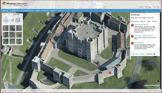
Bird’s Eye View: Now Includes UK
Live Local’s Bird’s Eye View, which provides multi-angled photographs from low flying aircraft, has now expanded to include large parts of the UK. While central London is not yet available, Steve did send me a screen shot, below, showing Dover Castle (a screen shot showing a different angle is here). The rest of the UK is being added shortly, and the Live Local team will be adding new cities and countries over time.