Microsoft will relaunch Virtual Earth tomorrow under local.live.com, around 9 am PST. This is a continuation of Microsoft’s rebranding campaign to place online consumer services under the Live.com brand.
Charlene Li had a briefing with Erik Jorgensen, GM of Microsoft’s new Search & Mapping group today and includes additional details on her blog.
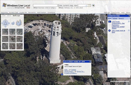
Local.live will also have new functionality. In addition to road maps and satellite views, Microsoft is beginning to integrate “birds eye” views, which are photos with significantly more detail than satellite pictures alone (see above screenshot). In addition, driving directions will be more fully integrated into the service.
This is a significant improvement on the existing service as well as a rebranding exercise. I’m still a big fan of Yahoo’s flash-based mapping service. The multi-point directions are absolutely a must have, and the constantly updating permalink saves a couple of steps when sharing a map. It does not include satellite images, however, which continues to be a drawback of the service.